Hawke’s Bay Civil Defence Emergency Management Group (HBCDEM) have made great progress with their tsunami signage programme in Napier, to ensure that people who live, work in, and visit the city are aware of its tsunami risk and how to stay safe this summer.
Five new Tsunami Information Boards have gone up at Marine Parade, Perfume Point, Spriggs Park and Westshore; Evacuation Route and Safe Location signs have been installed at Tiffen Park and Cameron Terrace; and nine new Leaving/Entering Evacuation Zone signs have been put up at key locations around Mataruahou (Napier Hill).
HBCDEM Community Engagement Advisor Pip Dixon has worked with Napier City Council (NCC) staff over the last few months to identify locations for the signs, and says they will play an important part in boosting community resilience in the area.
“We are particularly at risk of tsunami in Napier as we have the country’s largest and most active fault – the Hikurangi Subduction Zone – right on our doorstep,” Pip Dixon said.
“So, it’s important that people in our community are aware of the risk and know what actions to take to keep safe.
“We know that signage is an effective way to increase awareness and get those safety messages out to people,” Pip Dixon said.
NCC Executive Director Community Services Thunes Cloete says ensuring residents are safe and prepared for emergencies is a high priority for the Safer Napier programme.
“As a popular tourist destination, with some major events and a bumper cruise season, it’s important that we have these clear safety messages around our public spaces to help visitors know the risk too, and what actions to take to stay safe,” Thunes Cloete said.
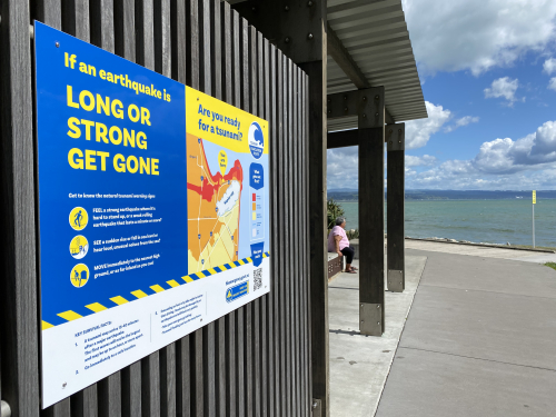
Tsunami Information Boards present awareness and action messages about:
HBCDEM’s signage programme has ramped up over the last year, with Napier’s new signs building on the three Tsunami Information Boards installed along Napier’s beachfront in 2022; nine new signs placed around Hawke’s Bay’s Cape Coast, and the region’s first ever tsunami ‘Blue Lines’ painted in Pōrangahau.
Pip Dixon says HBCDEM will continue to work with NCC to identify locations for additional tsunami signs and Blue Lines across Napier, with all signage planned to be installed by the end of 2023.
11 January 2023
Disclaimers and Copyright
While every endeavour has been taken by the Hawke's Bay Emergency Management to ensure that the information on this website is
accurate and up to date, Hawke's Bay Emergency Management shall not be liable for any loss suffered through the use, directly or indirectly, of information on this website. Information contained has been assembled in good faith.
Some of the information available in this site is from the New Zealand Public domain and supplied by relevant
government agencies. Hawke's Bay Emergency Management cannot accept any liability for its accuracy or content.
Portions of the information and material on this site, including data, pages, documents, online
graphics and images are protected by copyright, unless specifically notified to the contrary. Externally sourced
information or material is copyright to the respective provider.
© Hawke's Bay Emergency Management - hbemergency.govt.nz / / enquiries@hbemergency.govt.nz