The Hawke's Bay Civil Defence Emergency Management Group (HB CDEM) is monitoring and preparing for potential impacts of Ex-Tropical Cyclone Fili, and warning communities to get ready for the severe weather it may bring to the region.
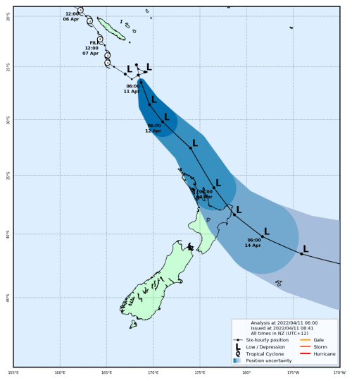
MetService is expecting Fili to approach the North Island from the subtropics on Tuesday, and then cross the country close to East Cape around midday Wednesday. This is likely to bring gales, heavy rain, large waves and coastal inundation to parts of the island from late Tuesday to Thursday. A Heavy Rain Warning and Strong Wind Watch are currently in force for Hawke’s Bay, through to 9.00pm Wednesday.
Group Controller Ian Macdonald said that Hawke's Bay CDEM had already moved to a ‘Monitoring’ mode of operation on Monday morning and will be activating the Group Emergency Coordination Centre in Hastings at 8am on Tuesday.
“Hawke’s Bay residents need to be prepared for heavy rain, strong winds and large waves,” Ian Macdonald said.
“We were briefed by senior MetService meteorologists this morning, and their advice is that Fili will be a fast moving but significant event, especially in the northeast of the North Island.
“Unfortunately, the brunt of the rain looks likely to once again impact the Wairoa District and Tairāwhiti where up to 300mm may accumulate in 24 hours, starting from late Tuesday or early Wednesday.
“We’ve had a day of planning, national briefings and regional coordination meetings and we’ve started contacting our community champions.
“We are monitoring the regional situation, activating our emergency coordination centre tomorrow morning and preparing to coordinate an effective and efficient emergency response if required.
“Councils have activated their incident management teams and started preparing their infrastructure and staff for possible impacts,” Ian Macdonald said.
Ian Macdonald said there is still some uncertainty with the exact track of the weather system, and changes in direction and speed will have a large effect on outcomes and impacts.
“MetService have advised the best certainty will come with the forecast on Tuesday morning and this will be a key decision point for us,” Ian Macdonald said.
Potential impacts of the severe weather could be power outages, road and transportation damage, and in some areas coastal inundation from swells.
“We already have wet conditions in Wairoa from the weather event in March, and any further significant rainfall will likely cause further slips and land damage on already saturated land,” Ian Macdonald said.
“We’re urging people in the region, particularly in our rural communities, to be prepared and to have a plan in place to respond to heavy rain and wind.
“Ensure you have enough food, fuel and supplies for at least 3 days and please reach out to your neighbours and those who were impacted during the last rain event to ensure they are prepared as well.
“Heavy rain can cause streams and rivers to rise rapidly. Surface flooding and slips are also possible.
“Driving conditions may be hazardous, so please drive to the conditions and if in doubt delay your travel.
“Everyone in Hawke’s Bay needs to keep up-to-date with the forecast and conditions over the next few days,” Ian Macdonald said.
People are advised to stay up-to-date with forecasts at MetService, and check for updates on the HBCDEM Facebook page and website.
How to prepare – what to do
11 April 2022
Disclaimers and Copyright
While every endeavour has been taken by the Hawke's Bay Emergency Management to ensure that the information on this website is
accurate and up to date, Hawke's Bay Emergency Management shall not be liable for any loss suffered through the use, directly or indirectly, of information on this website. Information contained has been assembled in good faith.
Some of the information available in this site is from the New Zealand Public domain and supplied by relevant
government agencies. Hawke's Bay Emergency Management cannot accept any liability for its accuracy or content.
Portions of the information and material on this site, including data, pages, documents, online
graphics and images are protected by copyright, unless specifically notified to the contrary. Externally sourced
information or material is copyright to the respective provider.
© Hawke's Bay Emergency Management - hbemergency.govt.nz / / enquiries@hbemergency.govt.nz